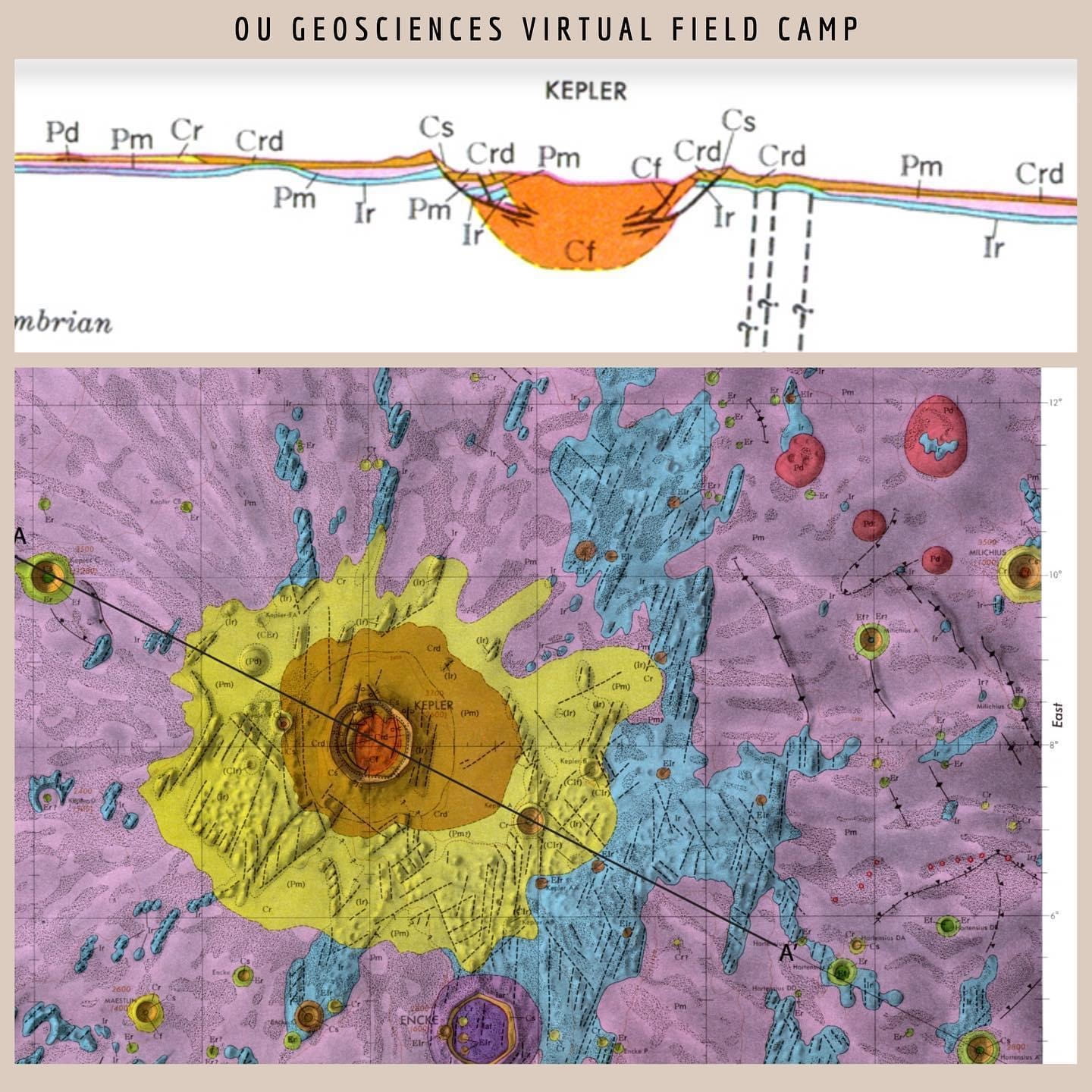
At virtual field camp you aren’t restricted to just mapping the Earth – students made cross sections while investigating the stratigraphy of Kepler crater… on the MOON!
By Shannon A. Dulin, Ph.D., Assistant Professor, School of Geosciences
dontpanicgeocast.com
When the decision was made during spring break to not return to classes, I immediately began to feel that familiar anxiety creep in on me. I mean, I always get anxiety as field camp comes near, because I want everything to go well. I don’t want anyone to get hurt. I want everyone to learn things. I don’t want friendships or relationships to get broken during the stressful six weeks living in close quarters in the hot Colorado sun. Most of all, I want everyone to have what I have – the great memories from all the camaraderie of hard work, hot days, long nights working on mapping assignments, and vast amount of knowledge I gained during my six week of field camp in Cañon City, Colorado.
The anxiety this year was different – we had nine students from OU and one outside student who needed field camp this summer to graduate. And I was going to have to teach field geology…online.
Even though I was extremely nervous about this prospect, I wasn’t all alone. I’m a member of the National Association of Geoscience Teachers (NAGT), and through them and my association with a field camp directors group, we organized Zoom meeting after Zoom meeting, starting in March, to come up with answers to how we were all going to do the impossible – teach online field camp.
Many schools cancelled their programs for the summer, but with students who needed the course to graduate, we did not have that luxury. Luckily NAGT has a vast online repository of geoscience teaching materials. Armed with this and our “Tech Thursday” Zoom meetings, we all were able to contribute new mapping exercises, revise old mapping exercises to make them work for field camp, and create an extensive menu of field exercises for any and all to use. I’ve never had a more productive spring semester; working with that dedicated group of individuals made me happy that so many people care about teaching our future geoscientists.
The crash courses in Google Earth Web edition, Google tour builder, and negotiating the many virtual geology worlds out there got my TAs and I on the right track to build the syllabus. In one NAGT workshop, I joined twenty other participants to create a set of nine learning objectives that we thought would guide us in building the curriculum for online field work. Since online work cannot take the place of field work, I decided to focus the online field course on the use of different software packages and how they interact with geoscience data. We paired this approach with a stratigraphy and mapping exercise we were able to build using videos and extensive photos of one of our regular mapping areas in Cañon City-Grape Creek. These exercises will teach student critical thinking skills while giving them wide exposure to the many ways they may interact with data in their future endeavors, whether that is graduate school or a job with a government, state, or private entity in the environmental or petroleum fields.
Experience Virtual Field Camp
Mapping a Virtual World
The first project that we introduced at virtual field camp was a mapping trip through a virtual world. The University of Leeds created these virtual worlds in a video game-type atmosphere. You have to go through the world, find outcrops, write down observations from a virtual field notebook, and freely navigate the landscape using a virtual compass and a printed topo map.
Field Camp…Meet Space Camp
We next delved into the world of Geographic Information Systems or GIS, since many jobs now use GIS software to manipulate data and build robust databases. One of the bonuses of online field camp is that we are not restricted to just exploring Earth! Alix Davatzes from Temple University and Brian Balta from Texas A&M developed mapping exercises on the moon and on Mars using the GIS software called JMARS.
JMARS was developed by Arizona State University’s Mars Space Flight Facility, and is what is used to load satellite and rover pictures from NASA missions onto a GIS platform. The students were able to map units on Mars using various rover and orbiter data. They also applied the stratigraphic principles of cross-cutting relationships and original horizontality to create a simplified stratigraphic column of units near Kepler Crater on the Moon. They then worked in groups to create cross-sections of the crater. Students learned about impact crater processes (something my master’s students have worked on) and the volcanic history of the moon.
Bartell Field Camp from Home
Two weeks of virtual field camp was devoted to looking at the Paleozoic section in and around Cañon City, Colorado, much as we would do during regular field camp. We had videos of me introducing the stratigraphy at stops all around Cañon City – stops that may ring familiar, like Skyline Drive the Florence Oil Field.
My TAs and I then assembled hundreds of photos of the mapping area in Grape Creek. Since students would be unable to take strike and dip measurements, we approximated these observations by taking along-strike oriented photos that displayed the azimuth of the formation. Students then used a digital protractor tool to record the dips of the formations in their notebooks. We took videos of rocks interacting with hydrochloric acid, so that students would be able to identify rock types. We took close-up photos with grainsize cards and captured hand sample images with a digital microscope. We also were able to create panoramic and 360° images of many of the outcrops. The students then built a stratigraphic column of the exposed units, many of which look like works of art!
The week after the stratigraphy was finished, the students used the same Google Earth Web landscape, augmented with hundreds more images, to map the unit contacts and create cross sections of Grape Creek. This is a typical mapping exercise that OU and other schools within the Cañon City Embayment participate in every summer. While we weren’t able to completely recreate the field experience, we were able to provide the students with all the data they would need to map the area…which they may have to do in future jobs or during their master’s work. It is one thing to be taken to a field area and led around, but another to have to plan your own exploration of the area (gently guided by myself and the TA) and make your own deadlines to assure you can complete the work. This is an invaluable skill to master before entering the workplace beyond college!
Virtual Field Trip to the Grand Tetons
The students were still able to go on a regional field trip, albeit a virtual one. Dr. Doug Elmore put together a google earth tour of the northern Rockies. Usually this is an in-person field trip to northern Colorado and Wyoming to explore Laramide structures, the Grand Tetons, and the overall tectonics of the area. This year the students virtually visited these places and were able to visit modern analogs of many of the depositional systems—which is something we don’t get to do in in-person field camp.
We used numerous other virtual field trips and mapping exercises during field camp, but as of this writing, I cannot divulge them – the students are currently working on them!
Thoughts about the Experience
In light of the turmoil in the United States, and the world, I’m glad I had the opportunity to work with my colleagues, my wonderful TAs, and everyone else who has banded together to make online field camp a reality. I know the students were disappointed to not visit Bartell Field Camp this year, but they did come away with a head full of knowledge about geologic process, software usage, and a series of job talks from colleagues who were able to visit the class via zoom.
Even though this is hopefully only an issue this year, the exercises that we’ve developed will be used in my Field Methods class in the coming years. My anxiety about students getting injured in the field was alleviated this year…although my back now realizes that my office chair could sure use an upgrade!
GIVE TO THE SCHOOL OF GEOSCIENCES